Website Search
Find information on spaces, staff, and services.
Find information on spaces, staff, and services.
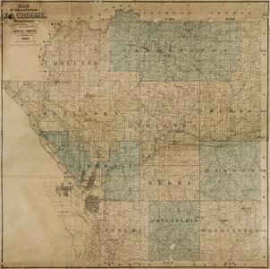
This group of materials includes maps and atlases of La Crosse County of a variety of types, including plat (rural land ownership), highway, soil, topographic; city of La Crosse (Wisconsin) including zoning, parks, and street; other La Crosse County municipalities; and representative pre- and post-lock and dam charts and maps of the Upper Mississippi River. The date range of this map collection is approximately 1854-1987 and explores the rich history of the area from the days of logging to the post-lock and dam system on the Mississippi River.
This project brings together in an online environment content that is located physically at three separate institutions: the La Crosse Public Library, Murphy Library at the University of Wisconsin-La Crosse and the Wisconsin Historical Society.
The city of La Crosse, Wisconsin, was founded by fur traders in the early 1840s and is located at a point where three rivers meet. This early industry quickly gave way to the lumber industry and Yankees and other settlers began to pour into the village. The city was chartered by the state legislature in 1856. While other industries began to spring up in La Crosse to help support agriculture and the lumber industry, the focus of the city continued to be the Mississippi River. La Crosse relied heavily upon water transportation for its contacts with others. The earliest road to the village was originally a Native American trail from Prairie du Chien along the Mississippi River. Slowly the town site grew from "six or eight houses" in 1850 to an astonishing population of 745 just three years later, according to an unofficial census taken by Rev. Carr in 1853. In 1851, La Crosse County was formed from Crawford County by the state legislature, and La Crosse was chosen as the county seat.
Sometimes La Crosse is spoken of in terms of North Side and South Side. The North Side was a separate village until 1871 when it became part of the city of La Crosse. The La Crosse River and a marsh that surrounds it is the dividing line between "North" and "South" La Crosse.
![[Hixon Reserve]](https://asset.library.wisc.edu/1711.dl/7JUHFBS7DNP4G8U/M/h300-165b9.jpg)
John Nolen was a nationally noted landscape architect who was hired by the La Crosse Park Board for two projects. One involved devising the first park plan, "The Making of a Park System in La Crosse…" (1911), and its associated map. Nolen laid out a master park plan which was adopted by the Park Board.
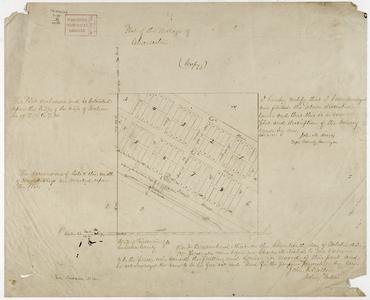
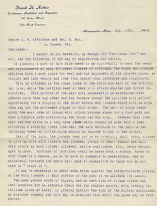
A few other maps related to parks are a part of this collection not created by Nolen include a landscape design plan for Pettibone Park by Frank H. Nutter Jr. (1902) and a companion manuscript letter from Nutter to the Pettibone Park Board discussing it. Also a map of La Crosse County's Goose Island Park (1960), and the city park area Hixon Reserve (ca. 1910-1919) which was later named Grandad Bluff Park are available.
The other major Nolen project for La Crosse involved the creation of a War Memorial in honor of World War I veterans which was never realized. Design plans for the project are included here, as well as a printed report for the War Memorial committee titled "Report on City Plan Covering the General Problems in their Relation to the War Memorial" (1919). Both the park system plan and the War Memorial project were early attempts for the city to create a partial land use plan before La Crosse had adopted any real plans for zoning and dedicated land use.
Materials related to Henry Bliss
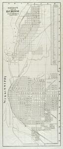
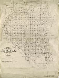
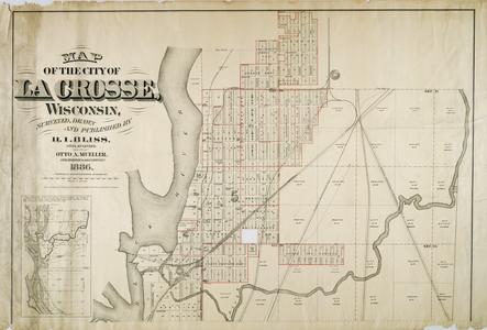
General city maps, mainly drawn by the city surveyor and later the City Engineering Department, span from 1857-1960. Henry I. Bliss was the first La Crosse city surveyor and engineer from 1857 to the late 1890s and he drew most of the large, detailed city maps and early county plat maps that form the nucleus of this project. Published maps by Bliss of the city of La Crosse span 1857-1893. Unpublished or manuscript Bliss maps of the city are generally undated, and are all courtesy of the Wisconsin Historical Society.
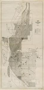
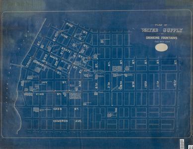
Other published maps in this group show specific aspects of the city, such as zoning, parks, the North Side, water pipes and the like. Also included here are the Minnesota and La Crosse Plank Road Company articles of incorporation 1873. The City Atlas of La Crosse (1898) is helpful in determining the placement and basic shape of building structures within the city limits up to that time, and researchers doing property research find it useful. Rascher's Fire Insurance Atlas from March 1884 with updates to October 1885 features the outline of structures and details not normally found on maps for downtown parts of the city. These specialized maps were created to help the fire insurance industry more accurately assess replacement costs for structure loss due to fire. This is particularly important to show where structures were located or sited and their geographic relationship in the city.
The lumber industry became the backbone of the La Crosse area economy from 1860-1900. This is represented by two maps showing the location of sawmills along the Black River in Onalaska, North La Crosse and La Crosse. Pine logs were floated down the Black River to Onalaska and La Crosse. Many sawmills had been constructed along the shoreline of the Mississippi River in a stretch from Onalaska north of La Crosse south to Isle la Plume on La Crosse's south side. However, most were located on the north side of the city near the confluence of the Black and Mississippi rivers. North La Crosse remained a separate village until 1871 when it was annexed into the city under what some North Side residents considered a hostile takeover.
Lumber greatly fueled the economy of both the city of La Crosse and the village of Onalaska. It was not uncommon for new immigrants to arrive in La Crosse and then to go and work for one of the large lumber mills, eventually earning enough money to buy his own property or farm. It was dangerous, long and hard work, and the newspapers are full of accounts of industrial accidents. Many New Englanders became rich from the seemingly endless supply of pine, but when the Wisconsin supply did run out near the end of the nineteenth century, these lumber barons moved further west or south to pursue lumbering as a source of capital.
The lumber industry also helped to encourage railroads to build in and near La Crosse. These lines concentrated again on the north side of the city, and each line had their own set of tracks. In October of 1858, the La Crosse and Milwaukee Railroad was completed, thus people and goods could travel from the east to La Crosse without having to make a steamer connection from farther down river. A more direct route from the Lake Michigan port city of Milwaukee to La Crosse afforded a much faster trip. Securing rail connections into the city was an important factor to the survival of the community. On November 18, 1870, La Crosse formally celebrated the completion of the Southern Minnesota Railroad from Wells, Minnesota, to the Mississippi River, thus connecting La Crosse with the west. A railroad bridge was completed in 1876 across the Mississippi River at North La Crosse. Until that time, railroad car ferries and winter ice bridges were used to cross the river. At one time, five rail lines came into La Crosse: Chicago, Milwaukee, St. Paul & Pacific; Chicago, Burlington & Quincy; Chicago & Northwestern; Green Bay & Western; and La Crosse & Southeastern.
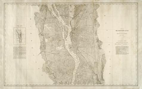
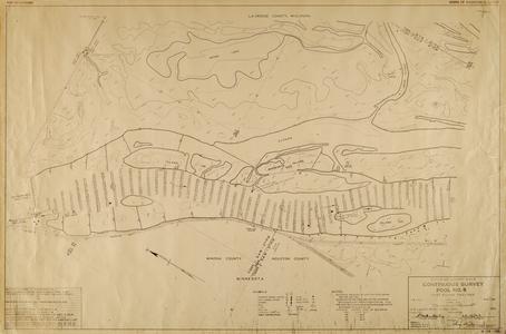
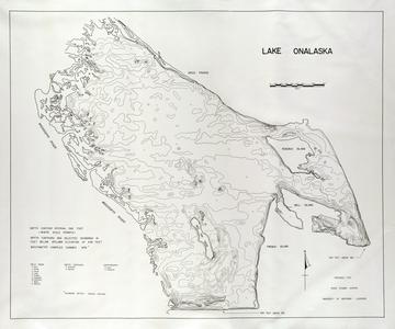
Upper Mississippi River maps include pre- and post-lock and dam maps. The lock & dam system and the 6- and 9-foot channel projects forever changed the river's landscape and behavior and were constructed in 1930. Farms and structures on Goose Island were condemned by federal officials before construction began, and Lake Onalaska was formed as result of the lock and dam system. Selected maps help to demonstrate these changes to the Mississippi River over time and include nine sets of navigation maps produced by the U. S. Corps of Engineers, 1872-1959 as well as six maps drawn by Bliss and are pre-1895. There is also a map of Lake Onalaska (1976).
These materials may be copied freely by individuals and libraries for personal use, research, teaching (including distribution to classes), or any other 'fair use' as defined by U. S. copyright laws. Please include this statement and author or photographer attribution with any copies you make. The materials may be linked to freely in non-commercial, non-subscription Internet editions created for an educational purpose.
Anyone interested in any other use of these materials, including for-profit Internet editions, should obtain permission from the institution that owns the material and which retains copyright for all other purposes. This information is noted in the bibliographic content that accompanies each item:
La Crosse Public Library
Archives Dept.
800 Main St.
La Crosse, WI 54601
(608) 789-7136
archives@lacrosselibrary.org
UW-La Crosse Murphy Library
Special Collections Dept.
1631 Pine St.
La Crosse, WI 54601
(0608) 785-8511
specoll@uwlax.edu
Wisconsin Historical Society
Archives Division
816 State St.
Madison, WI 53706-1417
AskLibrary@wisconsinhistory.org
Wisconsin Historical Society: Rights and Permissions Policy
Copied!
Maps and Atlases of La Crosse County, Wisconsin, and the Upper Mississippi River is a collaborative project completed by the UWDCC and the La Crosse Public Library.
Digitization of Maps and Atlases of La Crosse County, Wisconsin, and the Upper Mississippi River was funded, in part, through a 2008 Library Services and Technology Act (LSTA) grant. LSTA is governed by the Institute of Museum and Library Services (IMLS) which is the primary source of federal support for the nation's 122,000 libraries and 17,500 museums. The Institute's mission is to create strong libraries and museums that connect people to information and ideas.
For more information about LSTA grants in Wisconsin, contact the Wisconsin Department of Public Instruction (DPI) Division for Libraries and Technology or visit the LSTA grant website.